
Dinuba Previous Residents Source Eras
A house history works best as a source map. The Tulare County Assessor/Clerk-Recorder holds the durable land trail in Visalia, while directories, newspapers, census schedules, maps, and city files fill in the people who occupied or used a place. The table separates ownership evidence from household clues. “Years it covers” means the documented local span in the research record, not a promise that every year or every Dinuba address appears.
| Source | Years It Covers | Where Held | What It Shows |
|---|---|---|---|
| Recorder name and type index | 1960-present | Tulare County Recorder and Tyler kiosk | Indexed grantors, grantees, dates, and instrument types |
| Recorder document-number index | 1949-present | Tulare County Recorder and Tyler kiosk | An exact known instrument and its recorded details |
| Earlier deeds | Before the published online cutoffs | Recorder counter, lobby terminals, and microfiche | Older conveyances when the legal description can be matched |
| County directories | 1888, 1904-05, and selected years from 1930-58 | Tulare Public Library Genealogy Room | Possible occupants or businesses after Dinuba coverage is checked |
| Federal census schedules | Through 1950; California 1890 is missing | Federal census releases and library databases | Households, relationships, tenure, and enumeration geography |
| Dinuba newspapers | 1907-15, 1929-34, and 1909-2018 runs | Library microfilm and BMI Digital Reel | Moves, sales context, deaths, probate notices, and community ties |
| Dinuba Sanborn maps | 1891, 1898, 1903, 1907, 1925, corrected through 1944 | Library of Congress catalog and physical map research | Building footprint, use, and street continuity, not occupants |
| City permits and municipal files | Cutoff not published | Dinuba City Clerk and Planning and Development | Construction, changes, applicants, and records tied to an address |
Begin with the address and current parcel when the goal is a chain of ownership. Begin with a known surname and a dated directory or census when the goal is a former household. A deed can establish a transfer without proving that the grantee slept at the property. A directory can place a household at a street address without proving ownership. The strongest result is a matched sequence across both layers.
Dinuba Previous Residents Recorder Cutoffs
Tulare County’s public recorder index has an important asymmetry. The Tyler kiosk offers name searches from 1960 to the present, document-type searches from 1960 to the present, and document-number searches from 1949 to the present. It also offers map book and page and advanced search paths. A 1955 deed can therefore be reachable by a known document number even when a fresh online name search cannot find it. The index is a finding aid. The recorded instrument is the evidence that carries the legal description and signatures.
Use the Tulare recorded-document kiosk for the free index, then use the county copy instructions for an image or certified copy. Exact names are entered last name first without punctuation. Search spelling variants, initials, compound names, and older forms of a surname. The kiosk help supports required terms, exclusions, sounds-like searches, wildcards, fuzzy searches, quoted phrases, and alternatives, but no search form removes the need to compare the land details.
The recorder’s office is Room 103 at 221 S. Mooney Blvd. in Visalia. Public office hours are 8 a.m. to 5 p.m., with recording service listed from 8 a.m. to 3 p.m.; the office phone is (559) 636-5050. Images and copies are paid services. The published schedule lists $3 for the first page, $1 for each added page, and $2 for certification. Counter staff can explain how to retrieve a known record, but they do not perform or advise on a title search. For older material, use the lobby computers, counter assistance, microfiche, or a mail request when the online index stops.
Note: A 1955 instrument can be reached by known document number even when a fresh online name search cannot reach it.
Dinuba House History Deed Chain
The backward trail starts with a current parcel, not with an assumed owner name. Tulare’s MPTS property search accepts a street address, fee parcel, or assessment search, but the public result does not expose an owner or owner mailing address. Use the address to capture the APN, situs, legal shorthand, and current recorder document number and date. That document number is the bridge into the party-centered recorder index.
- Locate the parcel. Search the address in Tulare MPTS. For an address search, use a 2-20 character term, omit Street, Road, Drive, or Lane, and handle N, E, S, or W as the site instructs.
- Record the land keys. Write down the APN, situs, current document number, current document date, and any legal shorthand. These fields anchor later searches when the street label changes.
- Open the latest instrument. Search the known document number in the recorder kiosk and obtain the available image or copy. Read the indexed parties, legal description, APN references, deed date, and “mail tax statement to” block.
- Step back through the seller. Treat the grantee as the person or entity receiving that conveyance. Search the prior seller as a grantee to find the instrument by which that seller acquired the same land.
- Match before moving back. Compare the APN or legal description, recording date, parties, and parcel context. If the name matches but the land description does not, stop and test another instrument.
- Change access channels when needed. Use the document-number route for 1949-59 when a number is known. Move to the recorder counter, lobby terminal, or microfiche for older deeds, and use mail or copy service for a known instrument.
The result inventory may include party roles, recording date, document number and type, book and page, page count, and APN or legal remarks. The purchased image can add signatures, the full legal description, documentary transfer tax, and the tax-statement mailing block, subject to redactions. A deed of trust records a security interest. A reconveyance releases that interest. A lien records a claim. Those instruments belong in the chronology, but they do not all represent a change of resident.
- Grantor / grantee
- The grantor conveys an interest; the grantee receives it. In a deed chain, the earlier buyer may later appear as a grantor.
- Chain of title
- The ordered sequence of recorded instruments that connects a parcel’s present conveyance to earlier owners or interests.
- Legal description
- The formal lot, block, subdivision, or land description that identifies the real property more reliably than a street label.
- APN
- The assessor parcel number used to connect assessment data, maps, and recorded-document clues to a tax parcel.
- Criss-cross directory
- A reverse directory arranged by street and house number, useful for finding a printed occupant when a volume includes Dinuba.
- Enumeration district
- The census area assigned to an enumerator. It helps place an old address when street wording or boundaries differ.
Dinuba Address History and Parcel Changes
A street address is a useful starting label, but the APN and legal description carry the trail across map changes. Tulare County’s public parcel GIS shows parcel polygons, APN variants, lot and block details, map index, and creation or termination document numbers and dates. When one parcel is split, merged, or retired, follow the terminating APN to its creating or terminating instrument, then test the successor or predecessor APN in MPTS and the recorder index.
GIS search accepts an APN such as 123-456-789 or a one-line address or place. The viewer returns at most six suggestions or results, so a broad address may need a tighter search. Turn on the Tax Parcel layer and use the popup links to MPTS, the assessor map PDF, and the map context. The first three APN digits point to the assessor map book and the first six point to the book and page, an efficient way to narrow a physical map search.
Do not treat the Draw tool as an owner report. A circle, rectangle, or polygon can preserve a visual study area, but the viewer does not return a radius list or an owner list. Select the target parcel, record its identifiers, and then inspect each predecessor or successor one at a time. A changed APN may explain why an older deed seems to disappear, while a changed street name or an unverified local renumbering may explain why a directory search fails.
Note: The parcel fabric can connect a retired APN to a new instrument, but only a matched legal description supports a claim about the same land.
Dinuba Past Residents in Directories
Ownership is only half of a house history. The verified shelf list at the Tulare Public Library Genealogy Room includes a Tulare County Business Directory from 1888, a County Business/Resident Directory from 1904-05, and a six-county Regional Telephone Directory from 1908-09. It also lists Lindsay City and Tulare County for 1930-31, Tulare City and County for 1932-33, and selected R.L. Polk volumes for Tulare County from 1934 through 1958, with a Tulare-Visalia volume in 1955. Each book must be checked for Dinuba coverage.
A typical Polk entry may show a surname and given name, spouse notation, occupation, business affiliation, widow marker, residence, telephone, owner or occupancy symbol, and a cross-reference. A reverse section, when present, arranges streets and house numbers. That is a method description, not a confirmed Dinuba sample. The physical inspection should capture the title page, publisher, publication year, towns covered, abbreviation key, section list, and several known Dinuba streets before a volume is used as evidence.
Use the alphabetical section to find a name, then the street section to test whether the same household appears at the target address. Compare the preceding and following available editions. A missing entry can reflect a move, death, coverage change, survey refusal, or missed canvass. Do not imply that later volumes titled for Tulare City cover Dinuba when the shelf inventory does not say so. The confirmed historical directory collections themselves are described on the Dinuba city directory page.
Note: A county title alone does not prove that a volume contains Dinuba pages or a complete address section.
Dinuba Census Pairing for Households
Federal census schedules add household relationships that a deed or principal directory entry may omit. Identifiable schedules are available through 1950. Most of the 1890 schedules burned, and the California fragments do not survive, so the missing year cannot be filled by assuming a household stayed in place. Census address wording can also differ from a modern street label. Use the enumeration district, nearby streets, household relationships, and tenure as a dated layer beside the directory and deed trail.
- Establish directory coverage. Confirm that the county volume actually includes Dinuba and note whether it has alphabetical, street, rural-route, or business sections.
- Pair the closest years. Compare 1934, 1936, and 1937 directories with the 1930 census. Compare 1939, 1941, 1942-43, and 1944 with the 1940 census, then compare 1947-48, 1950, 1952, 1953-54, and 1956-58 with the 1950 census.
- Test the address context. Use the street section, house number, adjacent entries, census enumeration district, and household relationships together. A name alone is not enough when surnames repeat.
- Explain a gap before drawing a conclusion. A person absent from one directory may have moved, died, declined to answer, fallen outside the book’s coverage, or been missed by the canvass.
- Return to the land trail. Use the recorder for ownership, newspapers for moves or death notices, and probate for a legal estate trail. Keep the occupant sequence separate from the owner sequence.
This pairing process makes “who lived here before” a time-stamped question. The 1930 household, a 1940 street entry, and a 1950 schedule can describe the same address across three moments, but they do not prove continuous residence between the snapshots. Preserve the source title, year, page or image reference, and the exact printed address wording.
Dinuba Newspapers and Municipal Records
Newspapers can bridge the years when a former occupant appears in no deed. The verified runs are the Dinuba Advocate from 1907-15, the Dinuba Daily Sentinel from 1929-34, and the Dinuba Sentinel from 1909-2018, available through microfilm and BMI Digital Reel. The library newspaper holdings record is the best place to confirm the run before searching. Search notices for sales, moves, weddings, deaths, probate filings, civic service, and business associations, then compare the place and date with a deed, directory, or census entry.
Probate can close a former resident’s trail when a death notice supplies a name but not a clear family link. The Tulare Superior Court case system and its counter rules may identify a case number, decedent, personal representative, or public filing. Civil and probate copy work is commonly handled in Visalia, while Dinuba Division handles selected north-county matters. A newspaper lead should be matched to the case, property, date, or known relative before it is treated as the right person.
Municipal files answer a different question. A city council proceeding, board or commission roster, claim, historic document, or permit can place a person in a civic or property event without creating a resident census. Police records may name involved people, but release limits protect victims, investigations, and confidential information. Keep every municipal appearance tied to its record date and purpose.
Dinuba House History Through Sanborn
The Library of Congress catalog lists Dinuba Sanborn editions from August 1891, August 1898, June 1903, August 1907, May 1925, and a corrected set from May 1925 through November 1944. The corrected run contains 22 sheets, including North Dinuba, but the corrected 1925-44 set is cataloged rather than available as an online image. Sanborn maps show building footprints, use labels, and street continuity. They do not name occupants. Use them to test whether a structure existed, changed use, or sat on the same street alignment as a later address.
The Dinuba Sanborn catalog record works alongside assessment characteristics and permit files. Dinuba Planning and Development, at 1088 E. Kamm Ave., handles local permit and planning contacts. The research did not verify a public anonymous permit-history or code-case lookup. A targeted request should identify the address, APN, permit number if known, work type, and date range. A permit may name an owner, contractor, or applicant at filing time, but that name is not automatically the person who lived at the property.
For older construction, combine the Sanborn footprint with the parcel’s assessment characteristics, a city permit, and a deed legal description. A structure date from one source can narrow the search in another. A changed footprint can point to an addition or replacement, while a stable street line can help reconcile a directory entry with an older map. None of these sources turns a building into a complete list of former occupants.
Note: A permit applicant, tax mailing address, or deed party is not automatically the person who lived at the property.
Dinuba Previous Residents in Municipal Records
The Dinuba City Clerk is the municipal records route. The office at 405 E. El Monte Way keeps council proceedings, historic city documents, board and commission applications and rosters, Form 700 filings, campaign filings, claims, and records for related public authorities. These files can add a dated name, address, or property reference to a house history, but they are event records, not a list of everyone who lived in Dinuba.
The Dinuba documents and records hub is the official index for municipal document routes that can support a house-history request.
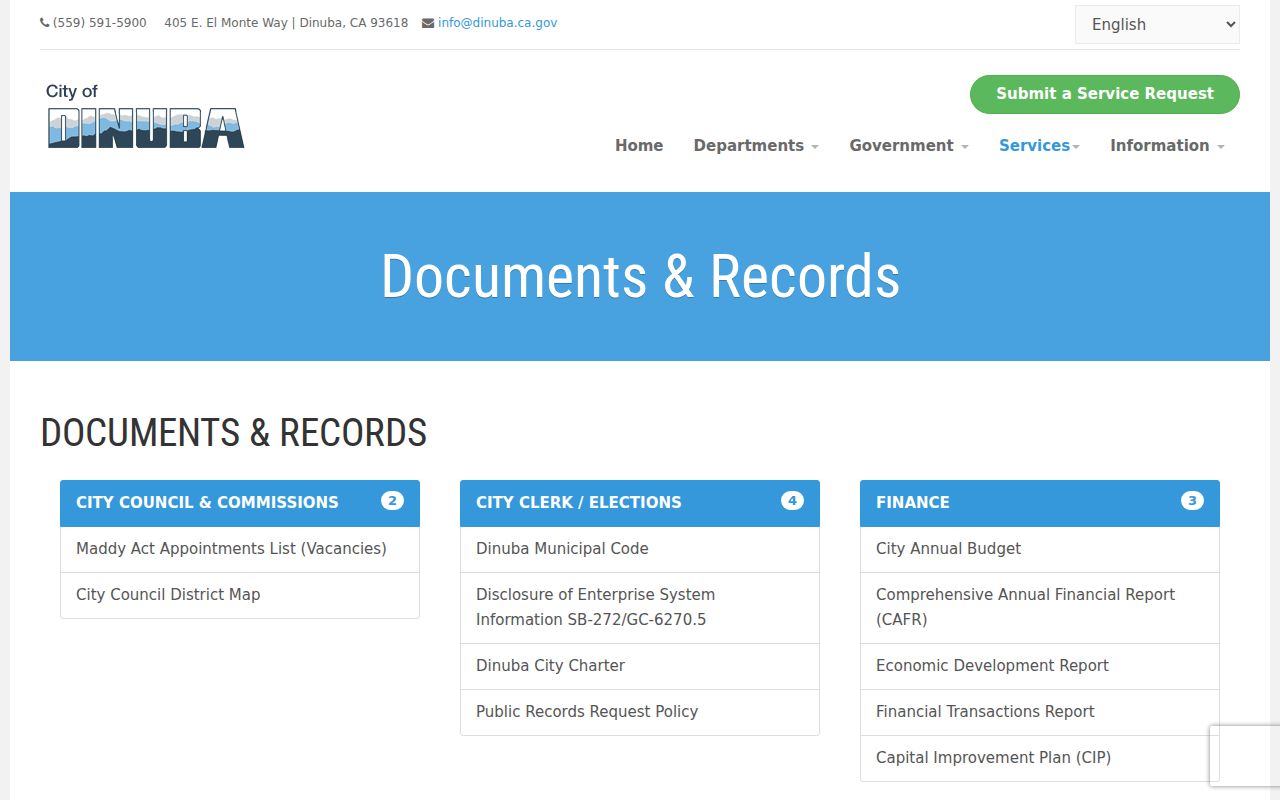
The hub is a route map, not a name list. For a historic permit, code file, business-license record, animal or alarm register, or other nonexempt address-keyed file, use the city’s California Public Records Act (PRA) request path. Dinuba’s policy asks for the requester’s name and contact details, a specific description by title or type and approximate date, the preferred format, and the delivery choice. The city provides a disclosure determination within ten days, charges $0.10 per paper page, and lists mail, fax, email, or inspection as fulfillment paths. A request can identify a situs and APN without claiming that the resulting file will name every past resident.
Dinuba's 1916 Library Story
Dinuba’s address history reaches beyond the city’s incorporation. James Sibley and W.D. Truxbury deeded 240 acres to Southern Pacific in 1888 for a depot and townsite, and Dinuba incorporated on January 6, 1906. A pre-incorporation trail therefore belongs to county and state land, voter, map, directory, and newspaper records rather than later municipal minutes.
Dinuba’s own library history explains why a physical research route matters. The branch began in 1910 in Dopkins Furniture Store, moved to the Snell Building and then the Chamber of Commerce, and received an $8,000 Carnegie library in 1916. The Chamber building and its contents burned in July 1916. The new Carnegie building opened four days later. That documented loss belongs to the library’s local history, not to an invented courthouse-record disaster.
The Dinuba Branch Library at 150 S. I Street is the local doorway to historical newspapers, county e-resources, BMI Digital Reel, and referrals to the Annie R. Mitchell History Room. The published schedule lists Tuesday 10 a.m. to 1 p.m. and 2 p.m. to 6 p.m.; Wednesday 10 a.m. to 1 p.m. and 2 p.m. to 7 p.m.; and Thursday and Friday 10 a.m. to 1 p.m. and 2 p.m. to 6 p.m. The direct phone is (559) 595-7195. Call ahead for physical directory access and copy rules.
No confirmed digitized Dinuba directory page or local house-history guide was located. That is a reason to ask the librarian which shelf, reel, or referral fits the address, not a reason to invent an online collection. Physical inspection, page references, and a note about the volume’s town coverage make a past-resident claim easier to audit.
Dinuba Previous Residents Known Gaps
Several gaps should stay visible in the final conclusion. The research did not locate an official digitized Dinuba directory entry, a confirmed local house-history guide, an exact reverse-directory run, a comprehensive official obituary index, a yearbook inventory, an exact first deed-book year, or a verified Dinuba street-renumbering date. The corrected 1925-44 Sanborn set is not online. MPTS has no public owner-name search, and the recorder’s published online cutoffs do not tell how far the older counter or microfiche holdings reach.
Those limits change the workflow. Use the recorder counter, lobby terminals, microfiche, mail requests, and paid copies when the online index ends. Use the library shelf and newspaper reels when a directory or obituary is not digitized. Use GIS parcel creation and termination documents when an APN changes. A blank search result is a source gap until the address key, coverage year, spelling, and access channel have all been tested.
Dinuba Previous Residents Privacy Limits
A careful house history keeps time and source type in view. A deed party is connected to a conveyance. A directory entry is connected to a publication year. A census household is connected to an enumeration date. A permit applicant is connected to a project. None is a live roster of residents. Non-owner occupants, household members, utility customers, delivery records, DMV addresses, protected voters, sealed court files, juvenile records, and Safe at Home participants may be absent or restricted.
California’s Safe at Home program can substitute an address prospectively for qualifying survivors and threatened people, but it does not erase public information already published. Voter information is purpose-restricted under Elections Code section 2194 and Government Code section 7924.000. When a protected record or substitute address appears, stop the trail and use the custodian’s stated access rules. A public-record request does not override an exemption.
Lawful house history. Dinuba previous residents research belongs to personal house history, genealogy, family reconnection, and lawful curiosity. Do not use records to stalk, track, intimidate, or harass a living person. California Penal Code section 646.9 and Civil Code section 1708.7 address stalking liability, and protected records must be left alone.
For a defensible result, retain the source title, date, page or document number, APN or legal description, and the reason each person was linked to the address. The Tulare real-estate fraud alert is a useful reminder to check unexpected transfers with the Recorder. The county private-solicitation warning also helps distinguish official copy access from paid mailers. The aim is a transparent chain of evidence about a place, not an unsupported claim about a living individual.